
When collecting elevation data it is important to make sure that you collect the best data possible. These 10 tips will help you to make sure your data is the best it can be.
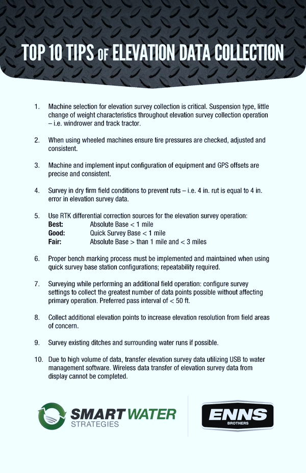
- Machine selection for elevation survey collection is critical. Suspension type, little changes of weight characteristics throughout elevation survey collection operation – i.e. windrower and track tractor.
- When using wheeled machines ensure tire pressure is checked, adjusted and consistent.
- Machine and implement input configuration of equipment and GPS offsets are precise and consistent.
- Survey in dry firm field conditions to prevent ruts – i.e. 4in. rut is equal to 4in. error in elevation survey data.
- Use RTK differential correction sources for the elevation survey operation:
BEST: Absolute Base < 1 mile
GOOD: Quick Survey Base < 1 mile
FAIR: Absolute Base > than 1 mile and < 3 miles - Proper bench marking process must be implemented and maintained when using quick survey base station configurations; repeatability required.
- Surveying while performing an additional field operation: configure survey settings to collect the greatest number of data points possible without affecting primary operation. Preferred pass interval of < 50 ft.
- Collect additional elevation points to increase elevation resolution from field areas of concern.
- Survey existing ditches and surrounding water runs if possible.
- Due to high volume of data, transfer elevation survey data utilizing USB to water management software. Wireless data transfer of elevation survey data from display cannot be completed.
These tips were written by Smart Water Strategies and ENNS Brothers.